


Page Topics:
Cost Approach
Land Computation
-
A parcel can have single or multiple land items and each item has different land computation methods.
-
Land items can be added to the newly created parcels which do not have any land item or can be added to the parcels which have land items.
-
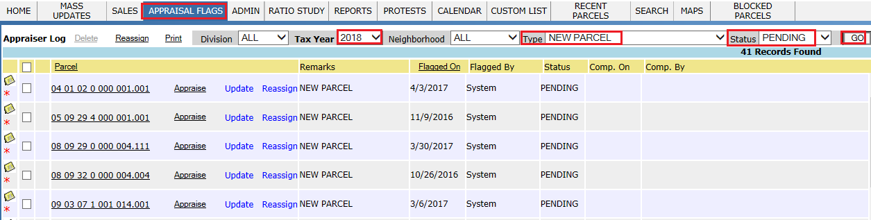
Appraiser user can get the newly created parcels through NEW PARCEL Flags (Under Appraisal flags) and add the land items to those parcels.
-
Land items are of different types like ACRE, LOT, SQFT, SITE. Every land Item should be categorized with one of these types.
-
Based on usage of land (land use code) and land schedule, unit price of land is fixed.
-
Market value of land depends on different factors like Influence Factor, Depth Factor, Acreage, Table Acres etc.
-
If the land is used for an agricultural purpose, Current Use will be applied on the parcel if the tax payer is eligible.
This document will walk the user through adding, updating land items, editing Home Sites and adding/updating Current Use on Land items in the Land Computation section of the PRC.
Adding Land Item to the Parcel
Login as an Appraiser User who has privileges to do land changes.
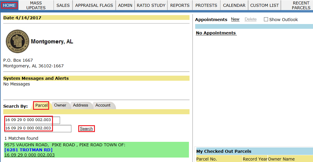
Step 1: Search for the parcel from the home page in which the land item should be added.
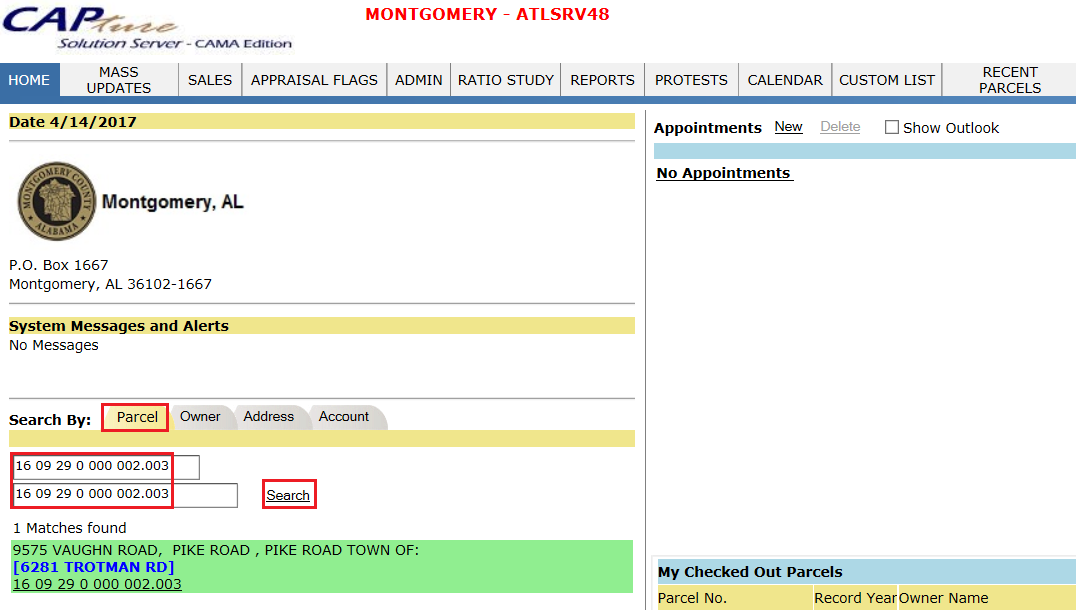
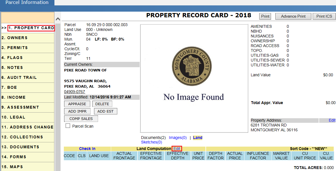
Step 2: Click on the parcel link and Check Out the parcel.
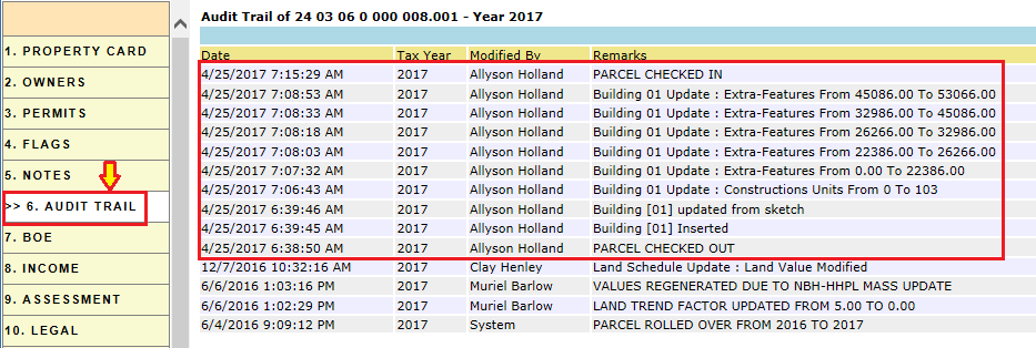
Verify Audit Trail: When a parcel is checked out it should be audited in the parcel Audit Trail.
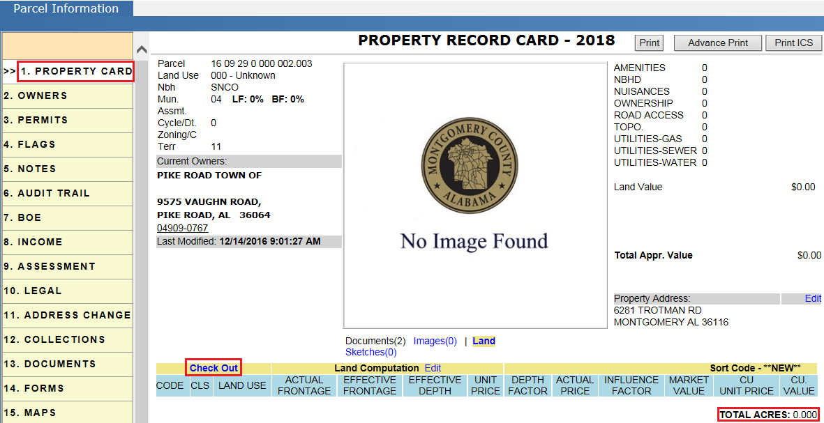
Step 3: To add land items, click on the Edit link (Land Computation region).
Step 4: Select the required attribute from the drop downs including Land Type, Code, Land Chart, Acres, etc. and click on the Add button.
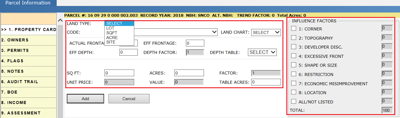
Land type: In Capture, land Items are of different types like ACRE, LOT, SQFT, SITE. Every land Item should be categorized with one of these types:
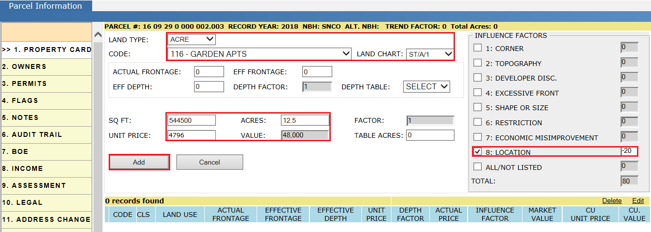
1) ACRE: Select Acre from the Land Type drop-down.
Required Fields to be Selected for Land Type ACRE:
-
Code: Land Use Codes identify how land will be used. For example: 111 Household Units, 113 Residential APTS, etc.
-
Land Chart: Determines the Unit Price used to calculate the value of the land based on various factors.
-
Acres: Enter the Acres based on the Legal. After entering the acres, Unit Price and Value (Value = Unit Price * Acres * Influence Factor) will be calculated automatically.
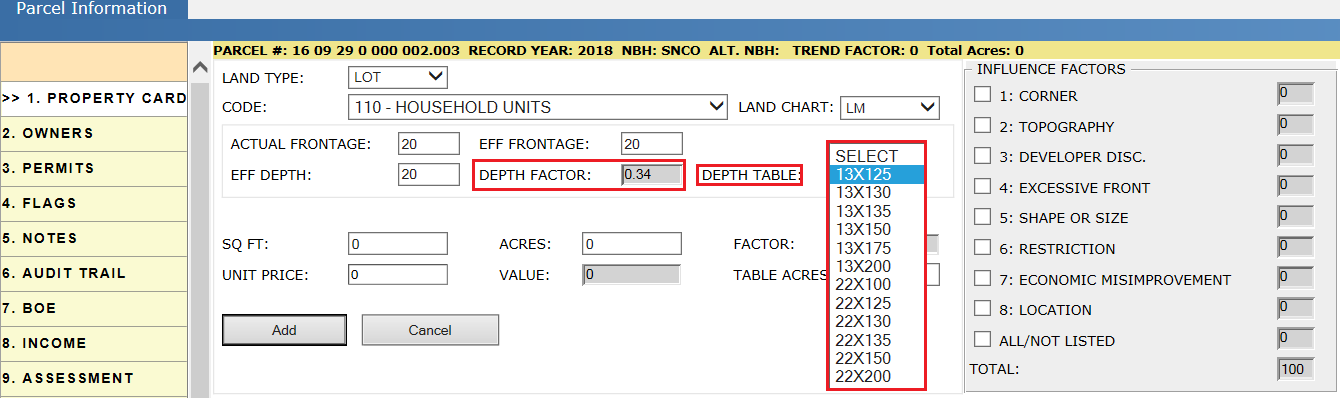
2) LOT: Select Lot from the Land Type drop-down.
Required Fields to be selected for Land Type LOT:
-
Code and Land Chart (LM) should be selected.
-
Actual Frontage: The frontage is the portion of the lot that abuts the roadway. If the property is irregular in shape, Effective Frontage and Effective Depth are used in determining the Lot Value.
-
Eff Frontage: Calculated by averaging the frontage and the rear lot line.
-
Eff Depth: Effective Depth is calculated by averaging the lengths of the sides of the parcel.
-
Unit Price: Enter the Unit Price based on the above factors. (Value = Eff Frontage * Unit Price * Depth Factor * Influence Factor)
-
Depth Table: Depth table determines the value of the Depth Factor. By selecting the different options from the depth table drop down, value of Depth Factor will be changed.
3) SITE: Select Site from the Land Type drop-down.
Required Fields to be selected for Land Type SITE:
-
Code, Land Chart (GM) and Unit Price should be selected. If required, select the Influence Factor.
(Value = Unit Price * Influence Factor)
4) SQFT: Select SQFT from the Land Type drop-down.
Required Fields to be selected for Land Type SQFT:
-
Code, Land Chart (SM), SQFT and Unit Price should be selected. If required, select the Influence Factor.
(Value = Unit Price * SQFT * Influence Factor)
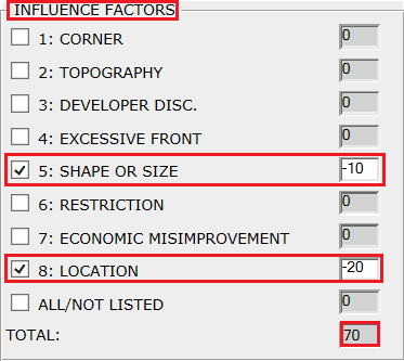
Influence Factor:
Influence Factor depends on where the parcel is located, shape and size of the parcel, Corner, Topography, etc. The user should select the factor which influences the parcel and enter the percentage it effects.
Influence Factor effects the market value based on the percentage provided.
Example:
-
Influence Factor percentage in Negative (-20, -30 etc.) represents reduction; means it will reduce the Market Value of the land.
-
Influence Factor percentage in Positive (like 20, 3, etc.) will increase the Market Value of the land.
Adding Land Item to Parcel: Select the required fields and click on the Add button.
Step 5: After clicking on the Add button, the land item will be shown under the Land computation section.
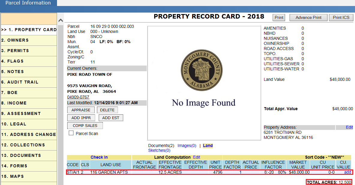
-
Total acreage of the parcel is shown under Total Acres.
-
A parcel can contain multiple land items with different land types. To add multiple land items to the parcel, follow the steps shown above.
Calculations:
Market value= Acres * Unit Price * Influence Factor
= 12.5 * $4796 * (80/100)
=$47,960 ($48,000) Rounded value.
Note: Rounding depends on Capture setup.
Updating Existing Land Items
To modify the information related to the land item like Acreage, Depth Factor, Influence Factor, etc., the user should check out the parcel and edit the land item. Then, modify the land with the required changes and click on the Update button.
Setup case: Updating the Depth Factor and Influence Factor of a land item.
Step 1: Edit the land item.
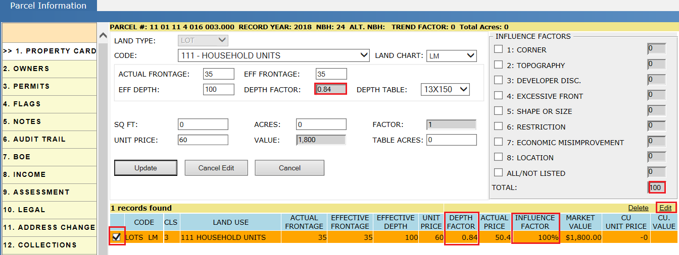
Step 2: Modify the Depth Factor and Influence Factor and click on the Update button.
Delete land item: Select the land item to be deleted and click on the Delete hyperlink.
Calculations (Before updating the changes):
Actual price = Unit price * Depth factor
= $60 * 0.84 = $50.4
Market value = Actual Price * Effective Frontage * Influence Factor
= $50.4 * 35 * (100/100) = $1,764 = $1,800 (Rounded)
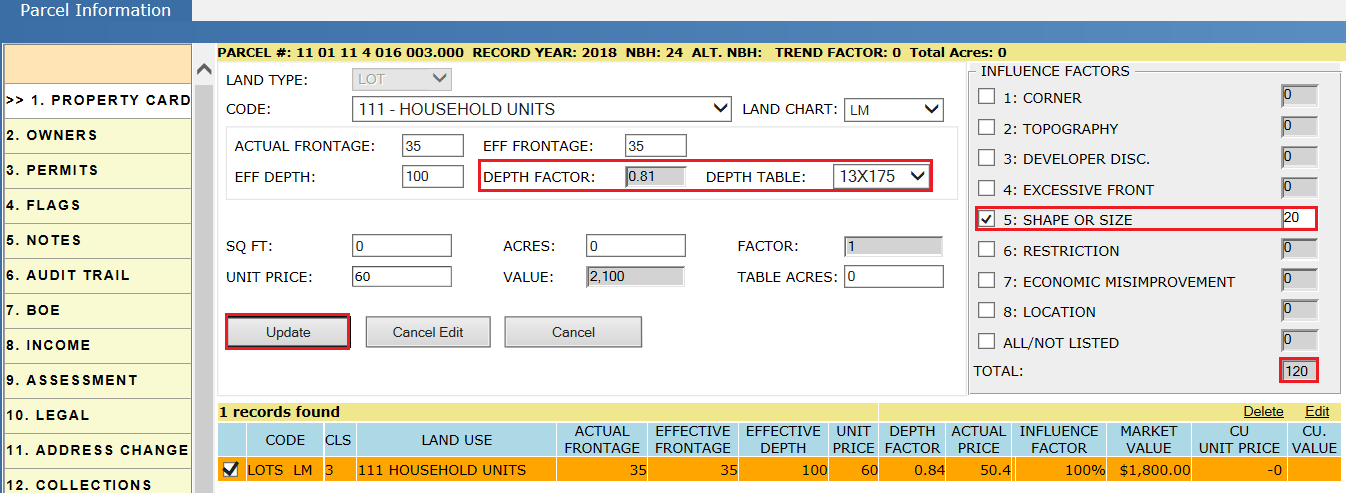
Step 3: After clicking on the Update button, as per the modifications, Market value of the land will be changed.
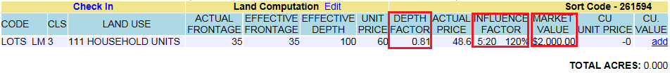
Calculations (After updating the changes):
Actual Price = $60 * 0.81 = 48.6
Market Value = $48.6 * 35 * (120/100)
= $2,041.2 = $2,000 (Rounded)
Contiguous Parcels
Contiguous Parcels are the parcels which are located side by side. If a taxpayer has 5 Contiguous parcels, adding the acreage of the 5 parcels together gives the Table Acreage. The taxpayers Unit Price will be less when compared with the individual land items Unit Price based on the land schedule.
Table Acres: It is used when multiple Land Types with different Land Charts are combined in one parcel. All acreages are combined to become the Table Acreage and the Unit Price of the Table Acreage is used in determining the value. Land items with has Table Acreage is identified with the * (Star symbol) on the acreage of land.
Note: As per the land schedule, if the acreage of land is more the Unit Price will be less and vice versa.
Adding Contiguous Parcels:
Step 1: Search for the parcel from the home page and check out the parcel. Then, go to the Assessment tab of the parcel.
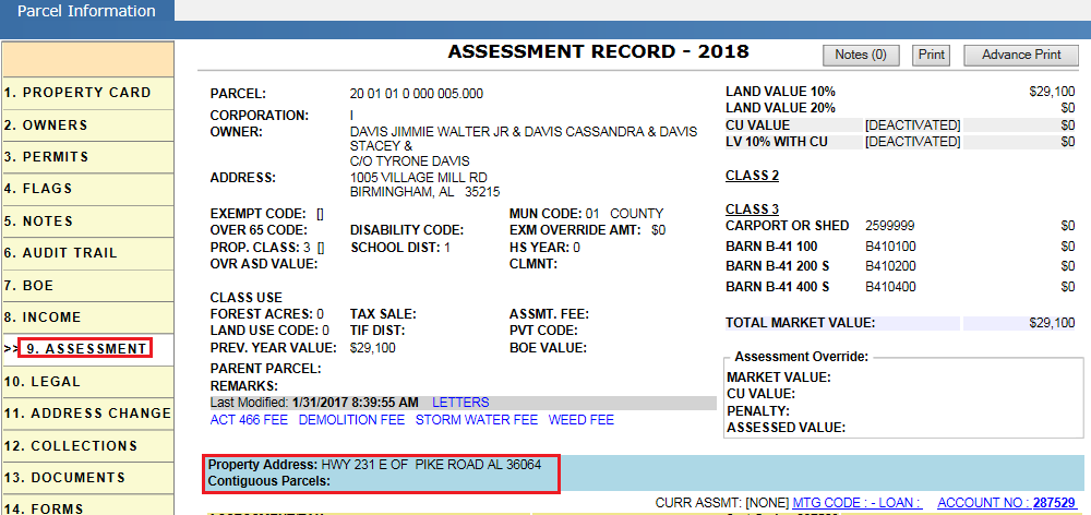
Step 2: Click on the Contiguous Parcels hyper region. Enter the contiguous parcel number and click on the Add button.
Added Contiguous Parcels can be found under Contiguous Parcels in the Assessment tab and in the Property Card tab with acreage in both parcels.
Step 3: Add both Contiguous Parcel acreages and make that acreage as Table Acres for both parcels’ land items (8 + 2 + 3.7 = 13.7 acres as Table Acres). After changing the land item, it should reduce the Unit Price of all land items.
Consider a land item with 8 acres and Table Acreage of 10 acres. Now, Unit Price for that land item is $8,325.
Calculations before changing table acres:
Market value = Unit price * Acres * Influence factor
= $8,325 * 8 * (135/100) = $23, 300
Step 4: Change the Table Acres of the land item to 13.7 acres and observe the decrease in the Unit Price of the land item.
Here, Unit Price of the land item is decreased from $8,325 to $7,025 and Market Value is changed from $23,300 to $19,700.
Calculations after updating Table Acres:
Market Value = Unit Price * Acres * Influence Factor
= $7,025 * 8 * (135/100) = $19,700
Similarly, update the Table Acres of the remaining land items of both Contiguous Parcels and verify the calculations.
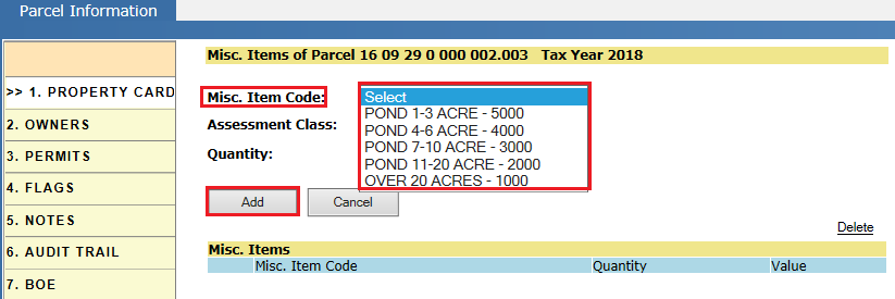
Homesites and Misc. Items
A Home Site is land which do not have buildings. There are different categories of Home Sites based on the usage of land like Water lines, Manufactured homes, etc. Values of the Home Sites are fixed as per the usage of land.
Miscellaneous Items like Ponds can be added to the land which do not have buildings.
Adding Home Site and MISC. Imp to a Parcel:
Step 1: Search for a parcel from home page.
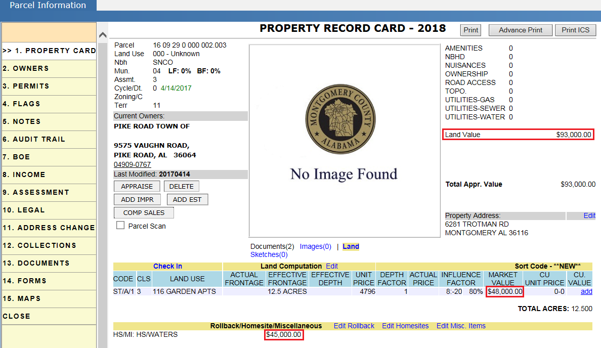
Step 2: Click on the Parcel link and Check Out the parcel. Then, click on the Edit Homesites link on the Property card tab.
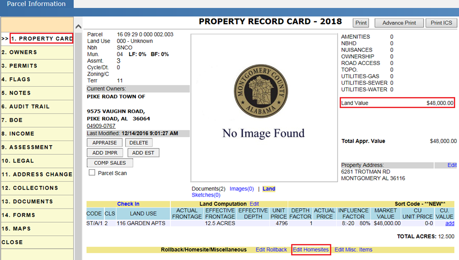
Verify the land value before adding Home Site to the land.
Step 3: Select the required home Site Code and click on the Add button.
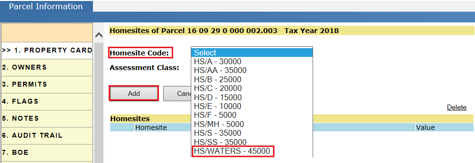
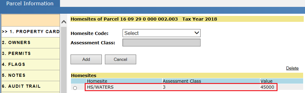
After clicking on the Add button, the Home Site will be added to the parcel along with the Assessment Class automatically.
Adding MISC Imp to Land: Similarly, to add MISC Imp item to land click on the Edit MISC Item link, select the item to be added, and click on the Add button. For verification, follow the steps used for Home sites.
Home Site value effects the Total Land Value of the parcel. Here, the Home Site has a value of $45,000 to be added to the $48,000 (land value) and the Total Land Value becomes $93,000.
Deleting a Home Site: To delete the existing Home Site, click on the Edit Homesites link and select the record to be deleted. Then, click on the Delete link. Deleting the home Site will affect the land value of the parcel and it should be audited in the parcel Audit Trail.
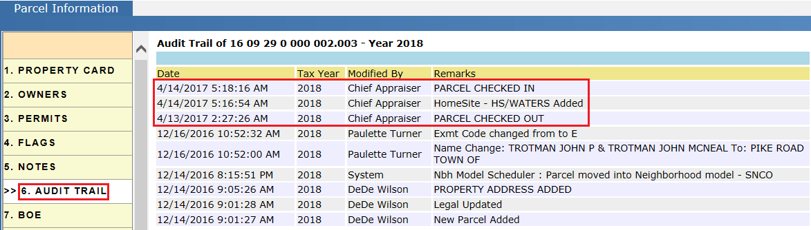
Audit Trail of Parcel After Adding Home Site:
-
It should contain Check Out, Check In audits with respective information.
-
Adding of Home Site to parcel should be audited.
Current Use on Land Item
-
If the land is used for Agriculture/ Farming purposes, it is considered as Current Use land. Unit Price of Current Use can be differentiated by using the CU Schedule. CU should be applied by the taxpayer who owns the land.
-
Current use is applied to the user (owner) not to the parcel. If the owner of the parcel is changed, CU will be removed on that parcel and new owner should go and apply for the CU if eligible.
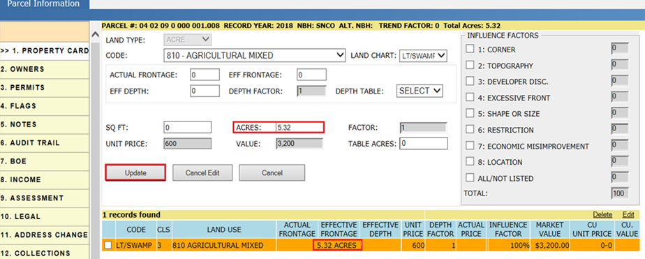
Setup Case: Parcel with a land item of acreage 10.32 is split into two land items. One land item with 5 acres and the other with 5.32 acres. CU is applied to the land item with 5.32 acres and the land type of the other land item of 5 acres is changed.
Case 1: Splitting the land item and adding current use to one land item
Step 1: Check Out the parcel and Edit the land item.
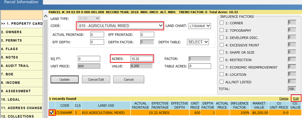
Step 2: Change the acreage of the existing land item. As it is going to split into 5.32 and 5 acres, make the acreage as 5.32 for the existing item and click on the Update button.
Step 3: Add the new land item with 5 acres. Select the fields (Land type, Code, Land Chart, and Acres) as per the requirement, then click on the Add button.
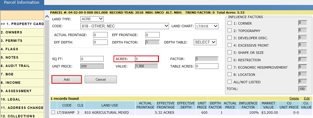
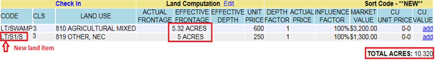
Verify the Land Computation section after adding the new land item:
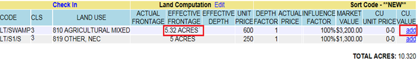
Step 4: Adding Current Use to the land item. Click on the Add link (under CU Value) for the land item to which Current Use is to be added.
Step 5: Select the CU Schedule required and click on the Update button. A pop up will appear to confirm adding the Current Use to the land item. Click on the Yes button.
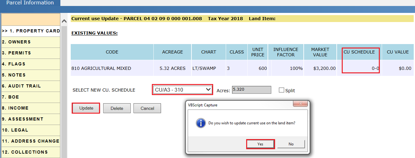
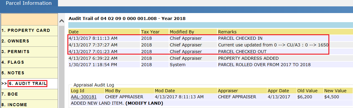
Verify the Audit Trail after adding the Current Use.
Verify the CU value and CU acres in the Land Computation section.
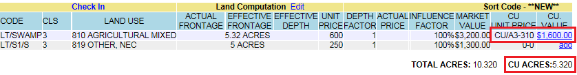
Calculations for CU Value:
CU Value = CU Unit Price * Acres
= $310 * 5.32 =$1,649.2 = $1,600 (Rounded)
Audit Trail of the Parcel after Adding Current Use:
It should contain details of the Check Out, Check In and CU update information.
Case 2: Splitting the land item and applying CU to one land item (Using Split).
Setup Case: Parcel with land of 5 acres is split into two land items by using the Split in CU region. One land item of 3 acres with CU and the other land item with 2 acres is automatically created.
Step 1: Check Out the parcel and click on the Add link on that land item.
Step 2: Check mark the Split, change the acreage and Land Schedule as per the requirement and click on the Update button. A pop up will appear to confirm adding the Current Use to the land item. Click on the Yes button.
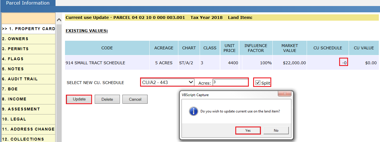
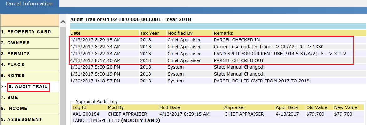
Verify the Audit Trail after adding the Current Use.
Split in CU region: If the user split the land by using the Split check box with the respective acreage, Table Acreage will be applied to the split parcels. Table Acreage is the total acreage of the existing land items. Both of the land items will take the same Unit Price in this process.
Consider a parcel of land with 5 acres, split it into 2 acres and 3 acres respectively, using the Split check box. Table Acreage for those two land items will be 5 acres and Unit Price is $4,400.
Step 3: After clicking on the Yes button, Current Use will be applied to the selected land item and a new land item will be created with the remaining acreage of the same code and land use.
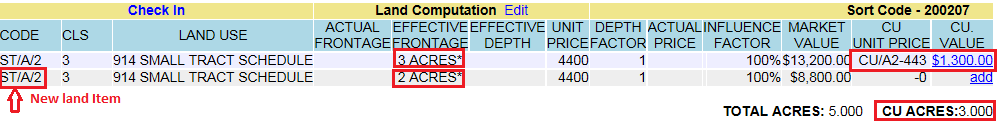
Verify the CU value and CU acres in the Land Computation section.
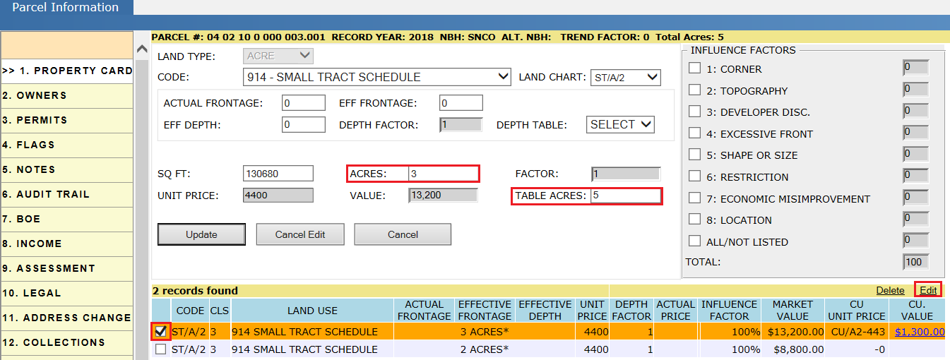
Verify Table Acres by editing the land item.
Note: CU value added for the land item will not be used till the CU gets activated by the respective user.
Updating Existing CU Item:
To update the existing CU value, follow the above steps. Change the required fields (CU Schedule, Acres) and click on the Update button.
Audit Trail of Parcel While Splitting the Land and Adding CU:
-
It should contain details of the Check Out and the Check In the parcel information.
-
Splitting the Land for CU should be audited.
-
Updating the Current Use information.
Reports Used:
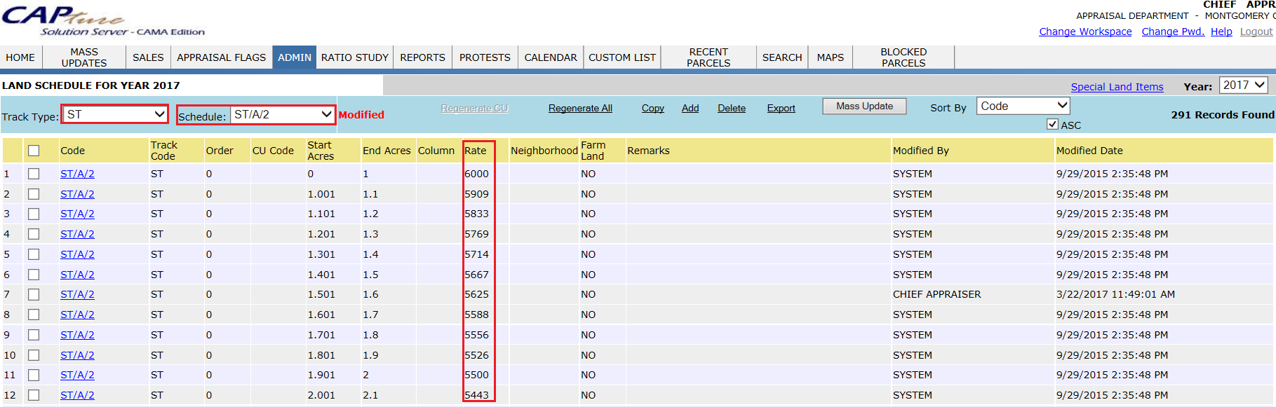
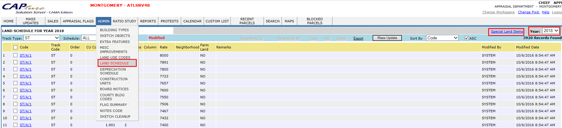
To know the Unit Price of the land with respective Land Schedule, click on the Land Schedule (Hover over Admin).
Appraiser user can check the NEW PARCEL Flags (Under Appraiser Flags) by selecting Tax Year, Type, Status, etc. as required. Then, add the land items to those parcels.
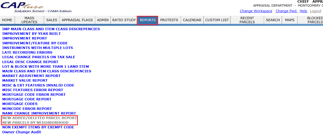
New parcels can also be found by using the Reports - New Added/Deleted Parcel and New Parcels by Neighborhood.
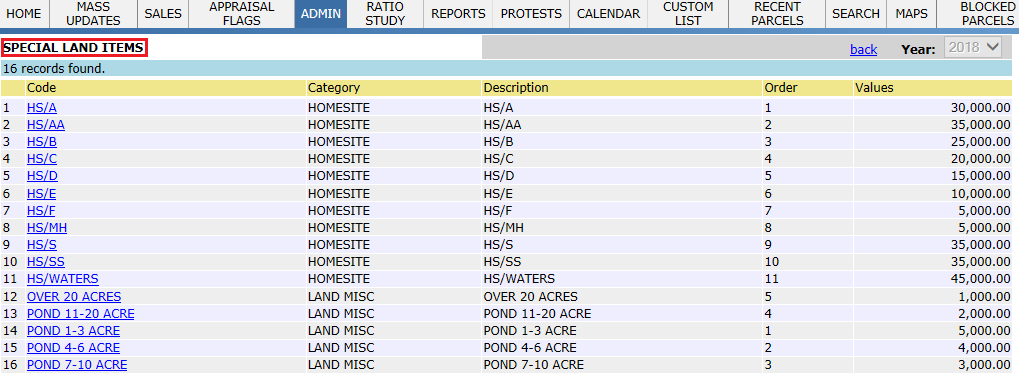
This report contains all the Special Land Items with Description & Value. Click on Land Schedule (hover over Land Schedule).Then, click on the Special Land Items hyperlink. Appraiser users will work on this report.
Adding and Updating Building
New Constructions or Improvements can be added to the PRC through Permits or field visits. Permits are the Rights/permissions given to the taxpayer by the county to make any kind of improvements to their property, it includes New Construction, Renovation or any other Extra Additions. Flags are created for the permits initiating a field visit. Permit Flags are available under Appraisal flags in Appraiser Workspace. This document will guide the user through adding New Building and Extra additions, both through the sketch and manually.
To add the building, login as Appraiser User who has privileges to add buildings on PRC.
Permit Flags:
Click on Appraisal Flags, Select the type as Permit Flag with status Pending and click on Go. It displays the permit Flags for the respective Tax Year.
For addition of buildings appraiser should work on New Construction Permits.
Permit Flags can be assigned to the privileged user by Reassign hyperlink.
Based on Capture setup all the permit flags automatically assigned to Appraiser Supervisor.
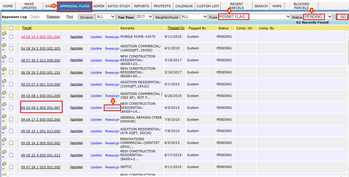
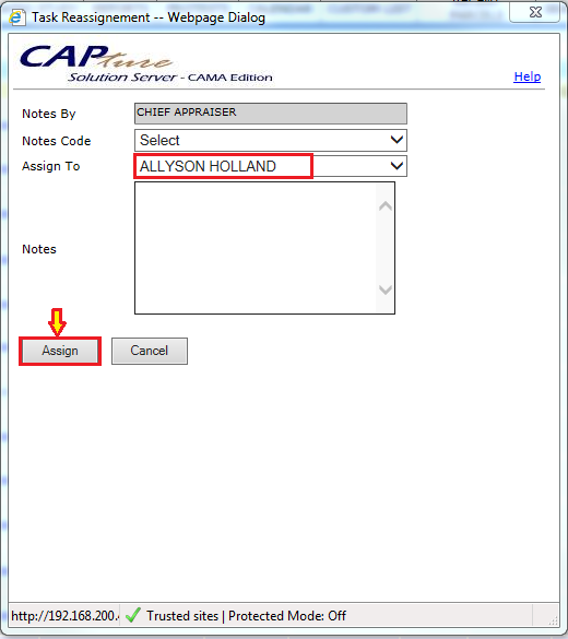
Re-assignment can be done by selecting the permit and then clicking on “Reassign”. Select the user and then click “Assign”.
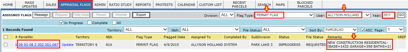
Login with the Appraiser user for which new construction permit flags are assigned.
User should click on the parcel and work on the permit assigned.
Steps involved in adding a Building:
Addition of Building contains following components:
-
Sketch
-
Construction Units
-
Extra Features
-
Miscellaneous Improvements
-
Appendages.
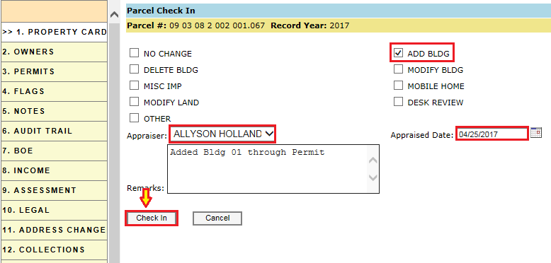
In order to add new building Check-Out the parcel.

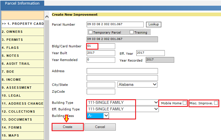
Click on ADD IMPR button to add new building.
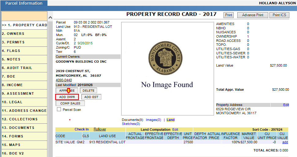
Enter the corresponding details like Bldg/Card No, building type, Effective building type and building class.
If the permit contains the addition of Mobile home or Miscellaneous Improvements, select the check box of Mobile home or Miscellaneous Improvement.
Click on Create, this will appraise the building automatically.
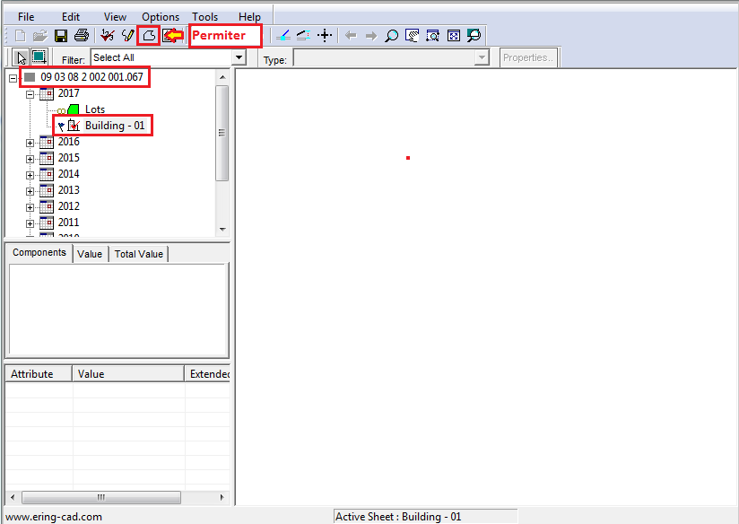
After clicking on create sketch control window will be opened. Expand Parcel number, record year and select the newly added building (Building – 01) to sketch.
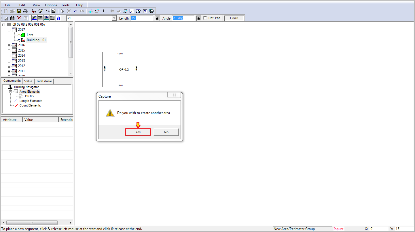
Click on Define area/ Perimeter symbol to start sketching.
After completion of particular area select corresponding Group Object Type and click on Ok.
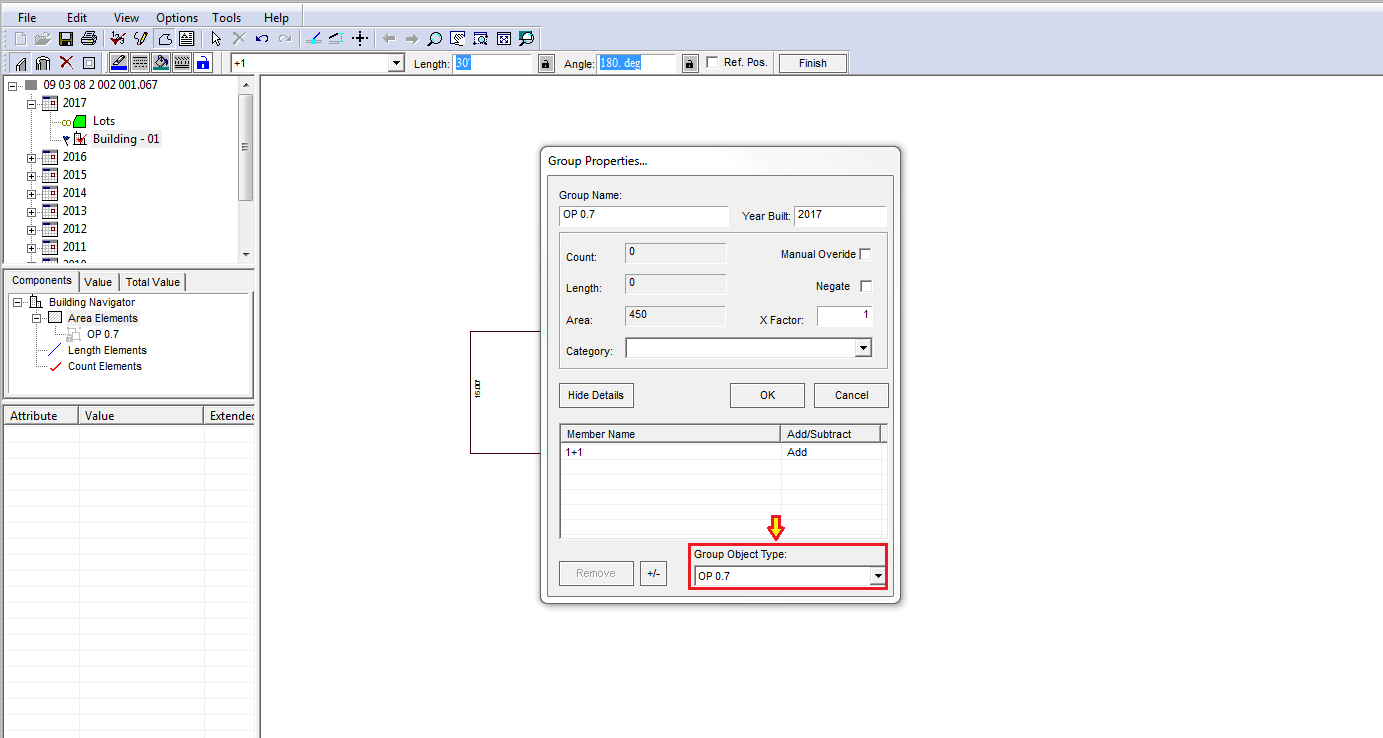
A pop up is displayed to continue the sketch with another area. Click on Yes to continue.
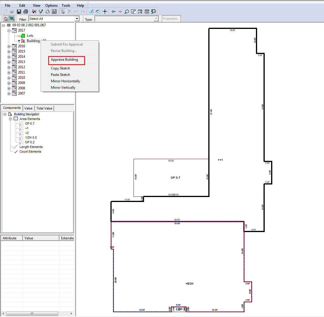
After completing the sketch, Appraise the building by right click on new building.
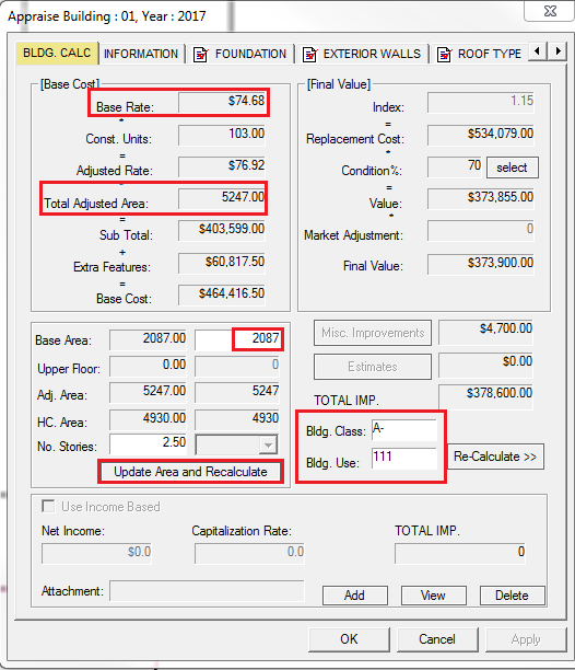
Appraise Building window will be displayed. Enter the details like No. of stories and click on Update Area and Recalculate button.
Based on Building Class,Base Area and Building Use, Base Rate, Total adjusted area, adjusted area gets calculated automatically.
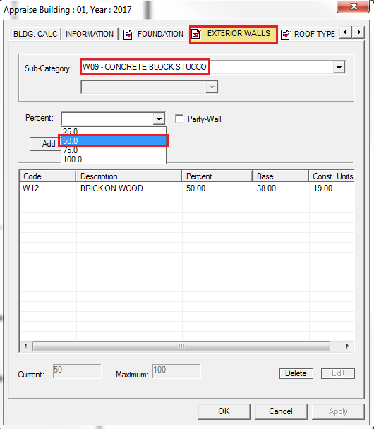
Construction units, Extra features are updated through the sketch in different tabs available in the Appraise Building Window.
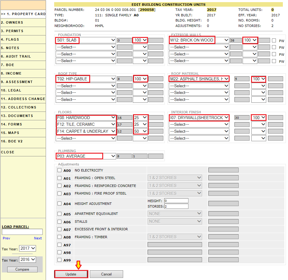
Select the type of Construction unit along with the percentage to add construction units to the building.
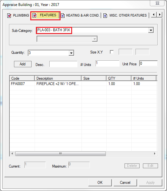
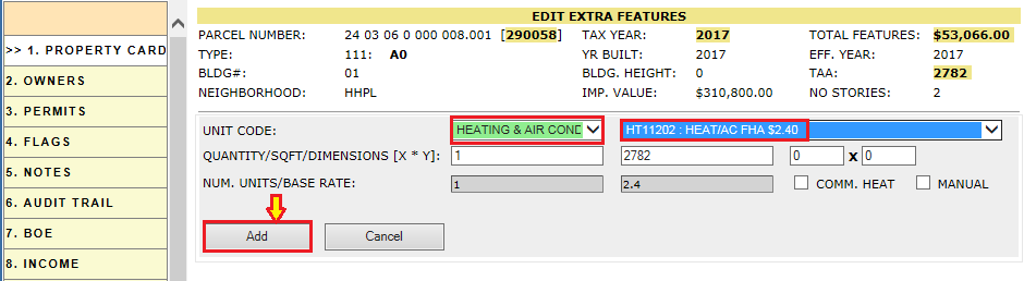
Similarly add the extra features by selecting the code of extra features and quantity through the features, Heating and air conditioner, Misc. other features tab.
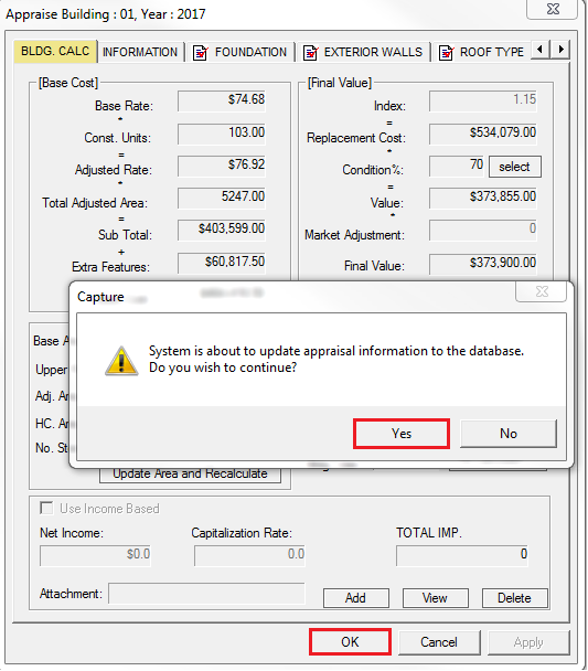
After adding the information click on Ok button. The below Pop up is displayed To update the appraisal information to the database. Click on Yes to update the information.
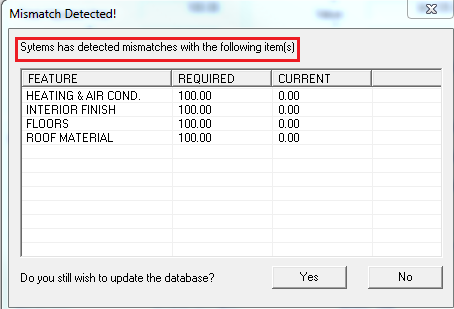
Note: If there are any incomplete construction units or extra features the system throw a Popup displaying the mismatch. Still we can update the database by clicking on Yes.
Verification: The updated information should be reflected in the PRC of the building.
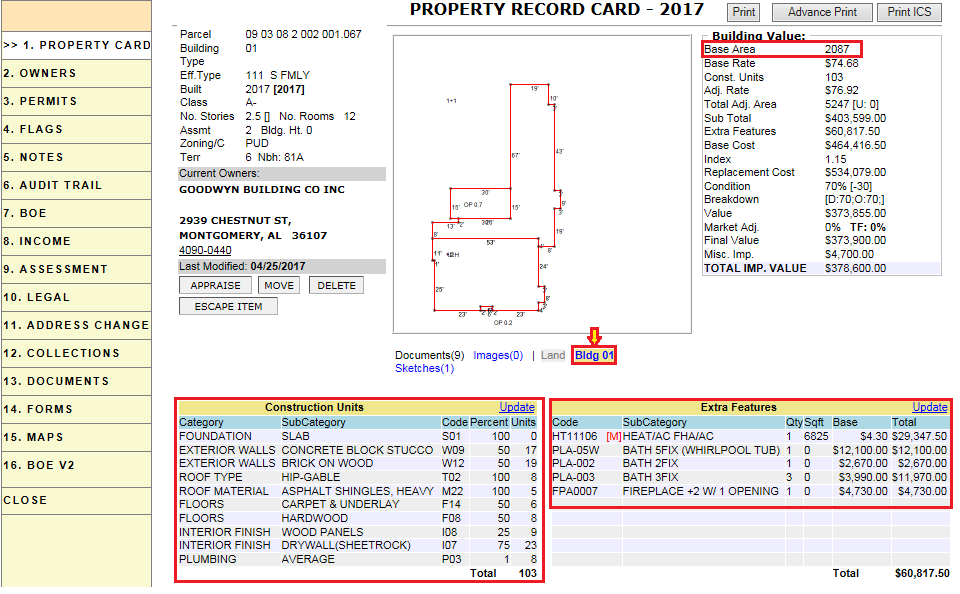
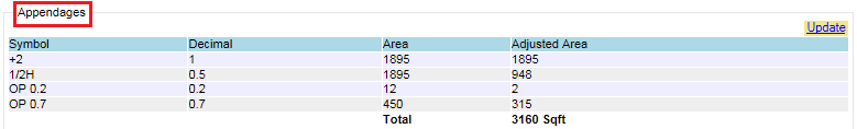
Verification: Areas that are added in the sketch should automatically gets added to Appendages.
Adding Misc Imp to the parcel
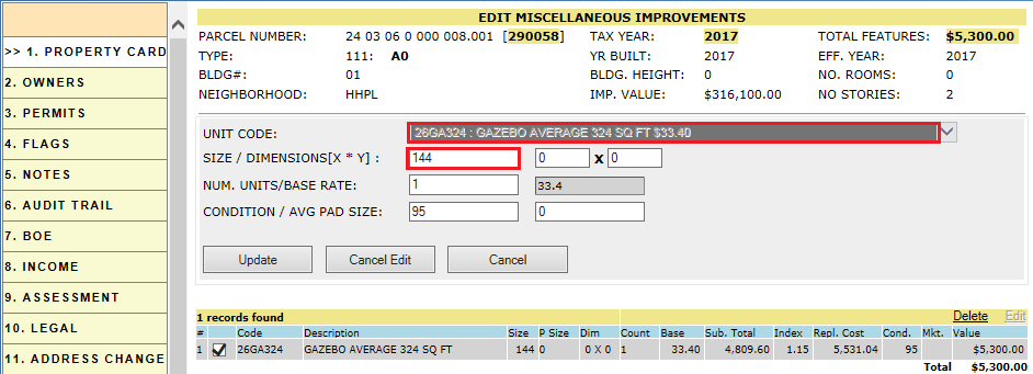
To add new Miscellaneous Improvements to the building, click on Update Hyperlink of Misc Improvement region on PRC.
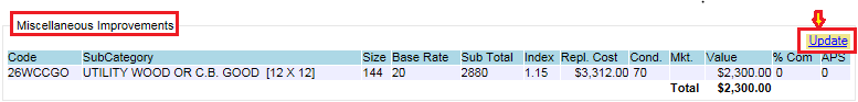
After clicking on Update button, Edit Miscellaneous Improvements page will be opened. Fill the respective information and click on Add button.
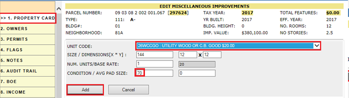
We can update the existing record in Miscellaneous improvement by clicking on edit hyperlink. Size, No, of units, condition can be changed. If there is any change in the unit code, the record should be deleted and add a new item.
Note: Miscellaneous Improvements can be added to building or separately in MI. Most of the counties show the Miscellaneous Improvements separately (MI).
Check in the parcel.
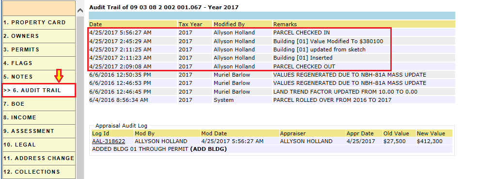
PRC Audit trail:
It contains the following information
-
Parcel Check out and Check In information
-
Addition of Building.
-
Building Updated information.
-
Building Value Information (If Modified).
Flags: For permit, initially the flag status is in PENDING.
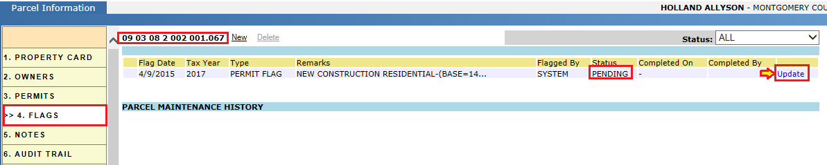
After adding new construction mark the permit as COMPLETED.
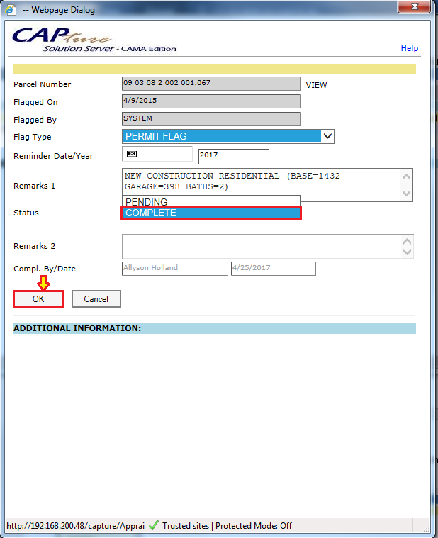
Note: The appraiser should mark the flag as completed to whom the flag is assigned.
Addition of building without sketch
Repeat the same process as described above for the addition of new construction.
Manually enter the base area, number of stories. We can change the condition of the building by clicking on Modify hyperlink. This will allow us to change the observed condition and click on update button of Building condition details.
We can also change the condition through functional and economic obsolescence.
This will change the condition and click on update button to update building value.
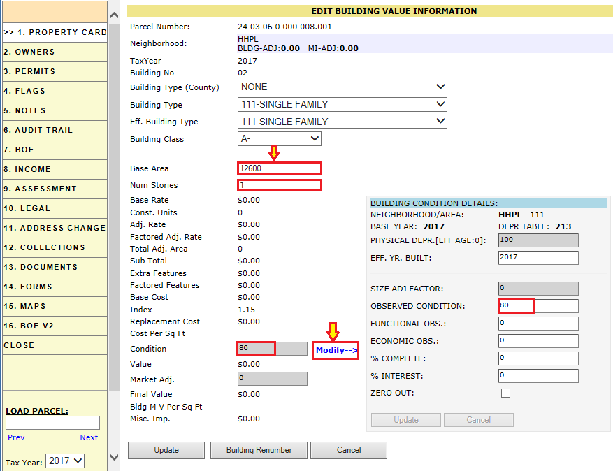
Note: Under building value hyper region, Base area is grayed out if the base area is updated through the sketch. As the base area, will be calculated based on the dimensions of the sketch.
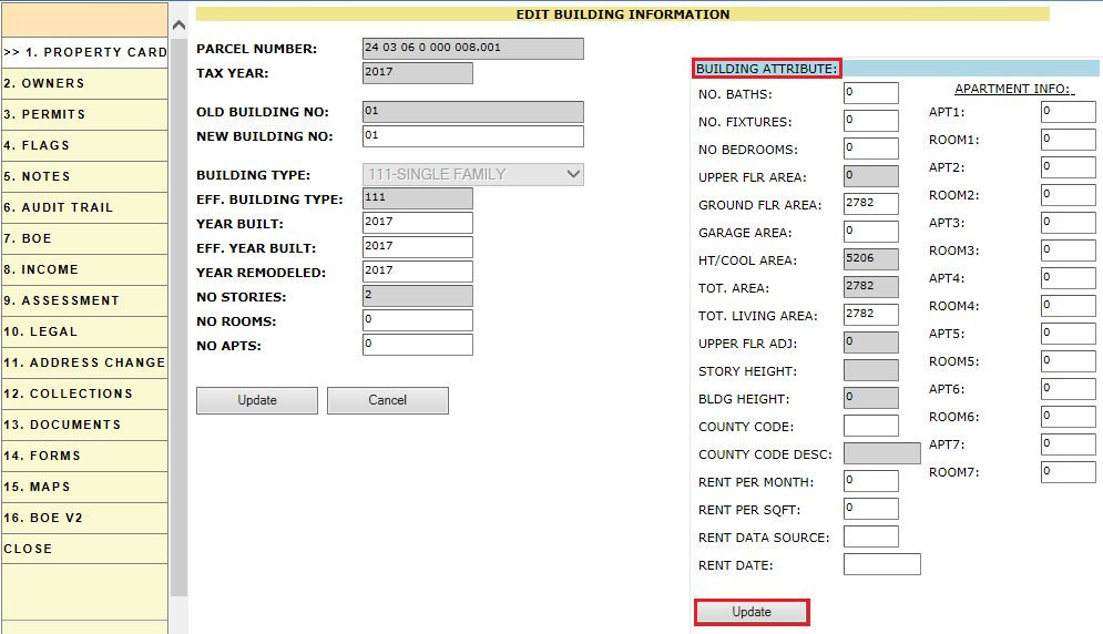
Under Parcel information hyper region building attributes like No. of baths, No. of fixtures, No Rooms etc., can be updated.
Addition of construction units and Extra features manually
Construction units, Extra features and Miscellaneous improvements can also be added manually after the completion of sketching. The process is described below.
Adding Construction Units
To add new Construction Units to the building, click on Update Hyperlink of Construction Units region on PRC.
Select the construction units along with the percentage and click on Update button.
Addition of Extra Features
To add new Extra features to the building, click on Update Hyperlink of Extra features region on PRC.
Select the Extra feature type, code, quantity and click on Add button.
Similarly add the Miscellaneous improvements.
PRC Audit Trail:
It contains the following information
-
Parcel Check out and Check In information
-
Addition of Building.
-
Building Updated information.
-
Updating Construction units.
-
Updating Extra Features.
Note: Extra features and Construction units that are added manually should be audited.

Confidential | Copyright © 2017 E-Ring, Inc.